

UNIGIS Master Thesis: UAVSAR vs. Sentinel-1: What SAR images reveal about the distribution of mangroves on the Pacific Coast of Colombia

This article presents a comparative study of SAR data from the Sentinel-1 and UAVSAR sensors, evaluating their performance for mangrove mapping along Colombia’s Pacific coast, one of the regions with the highest cloud cover in the eqautorial climate zone.
Why is it difficult to map mangroves in tropical regions?
Mapping mangroves in tropical areas presents numerous challenges. Nearly permanent cloud cover makes it difficult to acquire cloud-free optical imagery, while tidal dynamics and the structural heterogeneity of mangroves complicate land cover interpretation (Giri et al., 2011). In addition, many mangrove areas are difficult to access, which limits field validation and the collection of direct information. These conditions make it necessary to use technologies capable of acquiring data consistently, regardless of atmospheric conditions.
Synthetic Aperture Radar (SAR) as an alternative
Unlike optical sensors, SAR systems emit their own signal and record the energy backscattered from the Earth’s surface. This allows them to operate both day and night and penetrate cloud cover, a key advantage in tropical regions (Lucas et al., 2007). In ecosystems such as mangroves, the radar signal interacts with the canopy structure, tree trunks, and flooded ground, providing valuable information about terrain geometry and roughness. These characteristics make SAR a particularly suitable tool for monitoring coastal wetlands.
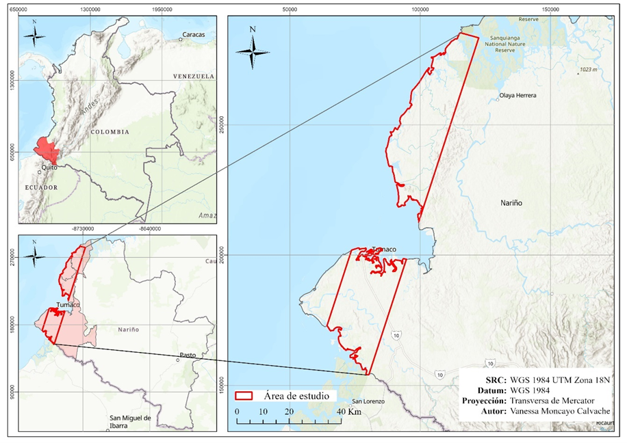
Study Area: The Pacific Coast of Narino, Colombia
The Pacific coast of the department of Nariño is home to extensive mangrove areas and is characterized by high rainfall, strong tidal influence, and persistent cloud cover. These conditions make the region an ideal setting for evaluating the potential of SAR imagery for mangrove mapping. The study focused on representative areas of this coastline, where mangroves play a fundamental role in local ecological and socio-environmental dynamics due to their contribution to biodiversity conservation, protection against coastal erosion and severe climatic events, as well as serving as a fundamental resource for the economic activities of the local population (e.g., fishing).
SENTINEL-1 and UAVSAR: How do they differ?
Although both sensors use SAR technology, there are key differences between Sentinel-1 and UAVSAR:
- Sentinel-1 operates in the C-band and offers global coverage, high temporal frequency, and free access to data, making it an ideal tool for continuous monitoring on a regional scale.
- UAVSAR, on the other hand, is an airborne sensor that operates in the L-band and provides higher spatial resolution and polarimetric capability, allowing for more detailed analysis of mangrove structure.
These differences directly influence how each sensor represents and discriminates with mangrove cover.
Main results of the study
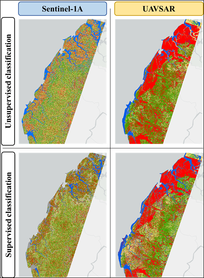
The results of this research showed that both sensors can identify mangrove areas, although with different performances. The UAVSAR data allowed for better delineation of the mangroves and greater structural differentiation, thanks to the greater penetration of the L-band signal and the polarimetric information available. In contrast, Sentinel-1 proved to be a robust tool for systematic monitoring, offering consistent results and broad spatial coverage, although with less detail in structural characterization.
The classifications revealed that combining variables derived from polarimetric processing improves the discrimination of mangroves from other land covers, especially when supervised approaches are integrated.
What do these results contribute to mangrove monitoring?
The study confirms that Sentinel-1 and UAVSAR are not mutually exclusive sensors, but rather complementary. While Sentinel-1 is ideal for temporal tracking and regional monitoring, UAVSAR provides a level of detail that is valuable for local studies and more specific analyses of mangrove structure. This complementarity opens new opportunities for designing more effective monitoring strategies, especially in tropical regions where atmospheric limitations hinder the use of optical sensors, thereby supporting coastal communities in the management of the vulnerable native mangrove ecosystems they inhabit.
For an interactive visualization of the methodology and results, please have a look at following Story-Map: Detection and Mapping of Mangroves with SAR Data (Spanish Language).
Referenzen
- Giri, C., Ochieng, E., Tieszen, L. L., Zhu, Z., Singh, A., Loveland, T., Masek, J., & Duke, N. (2011). Status and distribution of mangrove forests of the world. Global Ecology and Biogeography, 20(1), 154–159.
- Lucas, R., Mitchell, A., Rosenqvist, A., Proisy, C., Melius, A., & Ticehurst, C. (2007). The potential of L-band SAR for quantifying mangrove characteristics and change. Remote Sensing of Environment, 104(3), 347–359.
- Moncayo Calvache, V. (2025). Comparative analysis of SAR data from Sentinel-1 and UAVSAR for mangrove mapping on the Pacific coast of Colombia. Tesis de maestría, UNIGIS.


